
Chair’s Address
Mr Michael Burdett, Surveyor–General of South Australia
Hobart was the venue for our October meeting capping of a period of high activity for ICSM. The meeting had a strong focus on communication with our industry partners. Ahead of the formal two day meeting the Permanent Committee on the Cadastre (PCC) held a joint meeting with the Council of Reciprocating Surveying Boards of Australia and New Zealand (CRSBANZ) to discuss how the surveyors boards may work collaboratively with ICSM in achieving the goals set out in the Cadastre 2034 strategy document. This meeting also provided an opportunity for Prof Abass Rajabifard and Dr Serene Ho from the University of Melbourne to present on the work of the 3D cadastre research program. ICSM have been a sponsor of this research which will help us deliver the Cadastre of the future.
During the ICSM meeting we held an open forum with industry representatives. The session was well represented by local and interstate practitioners and provided an opportunity for ICSM to present an outline of its current work program. As importantly, it also allowed industry to engage with ICSM over matters important to them. The session generated active debate and I believe proved a valuable communication medium to all participants. I thank the industry members for making themselves available, particularly those who travelled some distance to attend.
With Cadastre 2034, the Foundation Spatial Data Framework project and the critical successful implementation of the GDA Modernisation on the current ICSM program, communication with our industry partners will continue to remain a strong priority for ICSM.
Committee Members
Following a restructure of roles at the Australian Geospatial-Intelligence Organisation (AGO), Mr Rohan Hill now represents AGO as their ICSM member. We thank Mr Graham Johnston for his contributions over the past 9 years and wish him every success in his future ventures and adventures.

The Committee for Geographical Names of Australasia name change
The CGNA at its recent meeting agreed to amend the current name of the working group to the Permanent Committee on Place Names (PCPN). This new title conforms to the current titles used by other ICSM working groups and corrects the geographically incorrect reference to ‘Australasia’.
FSDF Program Management Office and establishment of FSDF Registry
In July 2015, Geoscience Australia decided to set up a Program Management Office (PMO) to help with the delivery of ANZLIC’s Foundation Spatial Data Framework. Between August and December the PMO has undertaken a series of workshops with custodian agencies in each jurisdiction. The aim of these workshops is to clearly identify the number of, and who is responsible for, actual and potential datasets which contribute to national foundation spatial datasets. Information collected via this project will identify dataset mandates, internal funding models, lineage and other information already collected within jurisdictional metadata catalogues (to different degrees of completeness). This will be the first time that the supply of data has been formally recognized in the creation of national data sets and products. Understanding the dependencies between suppliers and products will also identify any risks in the supply chain.
The workshops have already identified 800 datasets in all jurisdictions that contribute to the creation of national spatial data products within the FSDF. This provides a clarity not previously possible to jurisdictions, aggregators, users and suppliers about the interdependencies and value of the datasets. It is hoped this will assist to develop business cases, to enable further funding for the development and maintenance of the datasets by jurisdictions.
The implementation of FSDF Program Objectives, Benefits and Outcomes, has changed the approach by which goals in individual theme roadmaps will be achieved. Consultations are also uncovering additional issues which will require treatment. It is likely that specific projects will arise that will require various levels of contribution from working groups drawn from data custodians across all jurisdictions.
The FSDF Program Management Office have also clarified components of the FSDF Work Program requiring expertise from ICSM Working Groups and Permanent Committees. These tasks are focused on technical advice relating to national and jurisdictional consistency and other measures of dataset quality, and the collation of known use cases for foundation spatial data within jurisdictions.
State and territory representatives have responded enthusiastically to the workshops and demonstrations of the FSDF Registry prototype. Data custodians are stating they recognise the value of the FSDF Registry and the direct consultation process in uncovering internal jurisdiction supply chain issues, potential opportunities to enhance existing datasets or create new products, and help provide business cases for redefining the role of individual custodian agencies to become “facilitators” of geospatial expertise rather than just data managers.
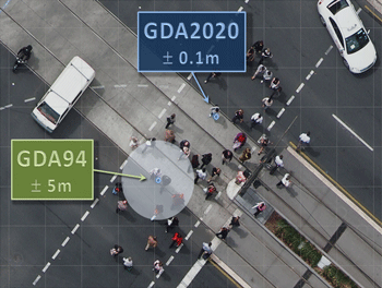
Modernising Australia’s datum
Following ICSM endorsement to begin a project to implement a modern datum for Australia, the GDA Modernisation Implementation Working Group (GMIWG) was formed in September 2015. At their inaugural face–to–face meeting held in October in Canberra, a total of 19 delegates attended the meeting with every State and Territory represented. The initial work of the group has been to begin the work to develop a national project plan and communication strategy. The group will meet monthly via teleconference to progress the national coordination of the implementation work.
During the first half of 2016, GMIWG will develop awareness material to assist all datum users with the transition to GDA2020.
Dr Hamed Olfat attends SEASC

Dr Hamed Olfat, Land Victoria’s ePlan Coordinator and Chair of the Technical Committee of the ICSM ePlan Working Group, attended the 13th South East Asian Survey Congress (SEASC) in Singapore from 28 to 31 July. Themed ‘Expanding the Geospatial Future’, the Congress provided a timely platform for government, industry and academia to discuss opportunities and challenges of geospatial data creation, maintenance and management particularly with regards to 3D cadastres and smart cities.
Approximately 450 delegates attended the Congress from many countries including Australia, China, Germany, Hong Kong, India, Indonesia, Japan, Malaysia, New Zealand, Philippines, Switzerland, United Kingdom and the United States. The Congress offered 15 Plenary discussion sessions, and more than 120 papers were presented during the technical sessions on a variety of topics such as cadastre innovation, 3D cadastre, advanced mapping techniques, Building Information Modelling (BIM), 3D data management, land administration and geospatial applications. The majority of speakers focused on the important role of new technologies (e.g. mapping devices, spatial databases and mobile applications) and 3D geospatial data as the main infrastructures in achieving the goals of a ‘Smart Nation|Smart City’ and addressing the challenges that our society has been facing with such as climate change, natural disasters, traffic, health, etc.
Hamed presented ‘Digital Cadastre: LandXML Implementation in Australia’ to the Congress. His presentation included an overview of the ePlan project at the national level, the exploration of the ePlan Model and LandXML Protocol, ePlan services (e.g. validation, visualisation, digital examination and DCDB automatic update), software vendors progress, and an overview of the ICSM Cadastre 2034 Strategy focus on 3D digital cadastre and concluded with a demonstration of the Victorian 3D ePlan Prototype. Speakers from the Singapore Land Authority (SLA), New South Wales Land and Property Information (LPI) and New Zealand Surveyor General’s Office also presented their willingness and strategies for moving towards a 3D cadastre system.
Hamed also visited the SLA on 31 July and held in-depth discussions with the relevant staff regarding the SLA 3D (Cadastre and Topography) activities and projects.
SLA joined the ICSM ePlan Working Group in 2013 and has recently adopted the ICSM ePlan Model as part of the Singapore Cadastral Survey Management System. The SLA staff members strongly acknowledged the ICSM ePlan Working Group efforts in developing such a comprehensive cadastral model. Delegates from the Philippines and Japan also showed interest to join the ICSM ePlan Working Group in the future.
Next ICSM meeting
The next meeting is proposed to be held in Christchurch, New Zealand on 1 & 2 May 2016 in conjunction with the FIG Working week.
Previous news letters
- July 2015
- December 2014
- December 2013
- August 2013
- October 2012 (.pdf file, 1.9 MB)
- February 2012 (.pdf file, 3.5 MB)
- June 2011 (.pdf file, 2.9 MB)
- December 2010 (.pdf file, 2.4 MB)
- June 2010 (.pdf file, 3.1 MB)
- December 2009 (.pdf file, 5.1 MB)
- June 2009 (.pdf file, 5.1 MB)
- December 2008 (.pdf file, 2.1 MB)
- June 2008 (.pdf file, 1.0 MB)
- December 2007 (.pdf file, 0.7 MB)
- June 2007 (.pdf file, 0.8 MB)
- December 2006 (1.7 MB)
- June 2006 (.pdf file, 1.2 MB)
- December 2005 (2.5 MB)
- June 2005 (.pdf file, 1.5 MB)
- 2004 (0.7 MB)
- December 2003 (.pdf file, 1.1 MB)
- June 2003 (.pdf file, 91.0 MB)
- November 2002 (.pdf file, 0.7 MB)
- June 2002 (.pdf file, 0.7 MB)
- November 2001 (.pdf file, 0.5 MB)
- May 2001 (.pdf file, 0.4 MB)
- June 2000 (.pdf file, 2.1 MB)