
Foreward

A more detailed list of ICSM’s achievements follows in this report.
During 2016–2018 the ICSM membership, went through a period of change. I would like to acknowledge the valuable contributions made by the following members over many years who retired or changed roles during this period:
- Mr Ron Jarman, (ACT)
- Cmdr Brett Brace (AHO)
- Mr John Tulloch (Victoria)
- Mr Paul Duncan (WA)
- Mr Paul Harcombe (NSW)
and we welcomed the following new members:
- Mr Jeff Brown, (ACT)
- Mr Rob Sarib (Northern Territory)
- Ms Narelle Underwood and Mr Wayne Patterson (NSW)
- Ms Annaliese Walster (WA)
- Cmdr Fiona Freeman (AHO)
Finally, with great confidence I hand over the chairmanship of ICSM to Simon Costello with whom I very much look forward to working with through his term in office.
Michael Giudici, Chair
1 July 2016 – 30 June 2018
Achievements During 2016–2018
- Audit completed of Historical Aerial Photography held by all jurisdictions, and scanning commenced to digitise and georeference the nation’s aerial photography archive.
- Software solutions developed to implement GDA2020 transformations.
- GDA2020 gazetted as new datum for Australia.
- GDA2020 Technical Manual published.
- EPSG codes updated to GDA2020 coordinates.
- GeodesyML adopted as an internationally recognised standard and endorsed by the International GNSS Service as the recommended way to transfer GNSS metadata via web services.
- First phase of FSDF road maps completed.
- LINK website established.
- ELVIS launched and is immediately successful in delivering large amounts of elevation data.
- Elevation 2030 Strategy developed.
- Gazetteer delivered through automated, streamlined process.
- New ICSM website launched.
- Research projects on 3D Cadastre and GDA2020 impact.
- Cross jurisdictional collaboration on SMES.
- Formation of Metadata Working Group (MDWG).
- CORS network upgraded and densified as part of NPI program.
COLLABORATIVE INITIATIVES
ICSM continued to support research by Centre for Spatial Data Infrastructures and Land Administration with Melbourne University -
- 3D Property Ownership Map Base for Smart Urban Land Administration
- Land and property management in 3D - http://www.csdila.unimelb.edu.au/projects/
Other Initiatives:
- Joint meetings of Permanent Committee on Cadastre (PCC) with CRSBANZ to achieve the goals set out in Cadastre2034.
- Progressing work with GA, Curtin University, LPI, LINZ, Landgate & CRCSI on new national geoid model.
Activities and Events
As part of our policy of engaging with spatial professionals; over the two years covered by this report, ICSM has had a significant presence at the following events:
- Locate17 Conference & International Symposium on Digital Earth — Sydney
- Locate18 Conference & GeoSmart Asia – Adelaide.
- United Nations Group of Experts on Geographic Names (UNGEGN) Congress, with Bill Watt continuing to be Chair of UNGEGN.
- United Nations Committee of Experts on Global Geographic Information Management (UNGGIM)
- United Nations Permanent Committee on GIS Infrastructure for Asia and the Pacific (PCGIAP)
As part of our strategy of informing about our activities; we:
- release the Minutes of ICSM Meeting every 6 months
- publish our Biennial Report every 2 years
- publish ICSM Newsletters
- routinely publish general information material.
About ICSM
Our vision
National land and marine spatial infrastructure providing sustainable benefits for Australians and New Zealanders
Our role
To provide leadership, coordination and standards for surveying, mapping/charting and foundational spatial data.
Who we are:
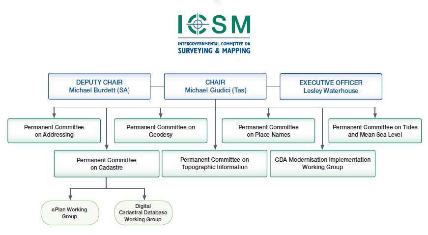
The Intergovernmental Committee on Surveying and Mapping (ICSM) is a standing committee of ANZLIC, the Spatial Information Council.
ICSM members represent 11 jurisdictions and are senior representatives of Australian and New Zealand commonwealth, state and territory surveying, mapping and hydrographic charting agencies.
ICSM is supported by a network of permanent committees and working groups. Working group members come from key government, academic, and private organisations from within Australia and New Zealand.
National
- Australia–civilian
- Australia–military (terrestrial and marine)
- New Zealand
Australian State/Territory
- Australian Capital Territory
- New South Wales
- Northern Territory
- Queensland
- South Australia
- Tasmania
- Victoria
- Western Australia
What we do:
As a key coordinating body in Australia and New Zealand for surveying and mapping issues, ICSM provides a forum that enables the exchange of information and ideas.
Our function is to:
- provide national coordination of surveying and mapping activities and research
- establish protocols and technical standards for spatial data and related infrastructure
- support the acquisition and maintenance of datasets forming the foundation data framework
- develop and publish best practice guidelines, national technical policies, standards, specifications and data models for foundation spatial data
- encourage a consistent approach across jurisdictions to spatial data policies, standards, programs and priorities
- provide technical advice and support to other coordinating bodies
- promote data integration
- provide a forum to share knowledge, experiences and expertise for foundation spatial data
- communicate and develop relationships with key stakeholders in government, industry and the user community.
How we add value:
ICSM’s activities support government and industry, and:
- provide national coordination, encouraging efficiency through consistency and cooperation, sharing best practice, and reducing duplication
- create enabling infrastructure (including products)
- support networking, learning and innovation across the surveying and spatial information sector
- increase advocacy for spatial information and surveying to improve efficiency and decision making.
How we work:
The ICSM Terms of Reference and Governance Charter is a set of rules that govern the conduct of our activities.
ICSM meets every six months and informs stakeholders of progress and activities through publications on our website and through email.
A Chair is appointed from the Committee every two years and an ICSM Executive Officer delivers secretariat and project support to members, Permanent Committees and working groups.
ICSM invites subject matter experts and key stakeholders to attend meetings to discuss items of mutual interest.
History
Prior to 1988, the National Mapping Council (NMC) coordinated Australian mapping programs. Although the NMC had been an effective forum, the changing operational environment required the formation of a national organisation to cover both surveying and mapping issues.
ICSM was established by the Prime Minister, State Premiers, and the Chief Minister of the Northern Territory in 1988. The Australian Capital Territory and New Zealand also joined ICSM.
In 2002 ICSM became a standing committee of ANZLIC—the Australian and New Zealand Spatial Information Council.
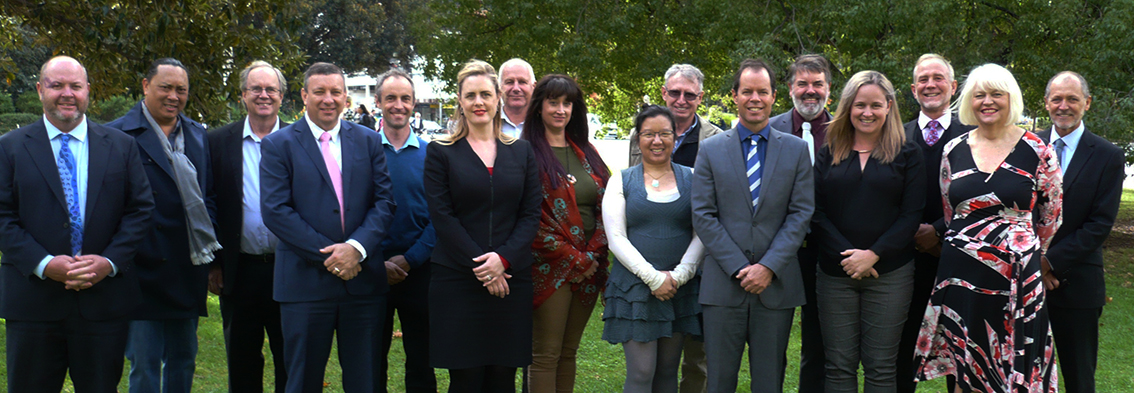
Left to right:
- Gary Johnston (Australia)
- Rob Sarib (Northern Territory)
- Russell Priebbenow (Queensland)
- Craig Sandy (Victoria)
- Simon Costello (Australia)
- Amelia Chapman (Victoria)
- Mark Dyer (New Zealand)
- Annaliese Walster (Western Australia)
- Zarina Jayaswal (Australian Hydrographic Office)
- Murray Dolling (Western Australia)
- Michael Giudici (Tasmania & ICSM Chair)
- Jeff Brown (Australian Capital Territory)
- Narelle Underwood (New South Wales)
- Wayne Patterson (New South Wales)
- Lesley Waterhouse (ICSM EO)
- Michael Burdett (South Australia)
Permanent Committee on Addressing (PCA)
Chair: Dr Greg Windsor, Manager Administrative Spatial Data, Department Finance, Services & Innovation NSW
Sponsor: Narelle Underwood, NSW Surveyor–General, Deparment Finance, Services & Innovation NSW
About PCA
The Permanent Committee on Addressing (PCA) aims to provide leadership in addressing, road naming and locality definition. This includes setting standards, developing guidelines, and promoting systems for the efficient interchange and sharing of addressing data.
Activities During 2016–2018
- The review of the AS 4590 Interchange of Client Information was chaired by Margie Smith.
- Committee was reinvigorated with new Chair and Sponsor in 2017, and delivered new Terms of Reference for the group.
- Relationship between geocoded addressing and place names was investigated.
Permanent Committee on the Cadastre (PCC)
Chair & Sponsor: Dr Russell Priebbenow, Director, Cadastral and Geodetic Services, Director of Surveys,
Department of Natural Resources and Mines, Queensland
About PCC
The Permanent Committee on the Cadastre (PCC) was established in 1999 to provide a leadership role in:
- advising ICSM on cadastral matters
- raising awareness of the cadastre and the benefits of the digital cadastral system to the spatial industry and the community.
Its role is to develop a coordinated approach to cadastral maintenance and improvement of digital cadastral data. This incorporates involvement with all stakeholders, including other peak government and industry groups.
Activities During 2016–2018
- Several research projects in collaboration with RMIT, Melbourne University and the CRCSI to assist in achieving goals set out in the Cadastre2034 strategy, particularly in regard to 3D cadastre.
- Workshops conducted by Dr Don Grant to finalise his research paper for PCC.
- Joint meetings regularly held with CRSBANZ to progress work towards the goals set out in Cadastre2034.
- Work being progressed to establish state borders cartographic representation dataset, with the river boundaries between Queensland/NSW/Victoria taking longer than expected to determine.
- Definition of “Property” paper completed by Bill Hirst for PCC.
- Terms of Reference of PCC updated to align with Cadastre2034 and ICSM goals.
- Further work and discussions on the implementation of 3D cadastre.
- Continued support on the Land Parcel and Property Theme of the Foundation Spatial Data Framework.k.
ePlan Working Group (ePlan)

Chair: Dr Hamed Olfat, ePlan Coordinator, Department of Environment Land Water & Planning Victoria
Sponsor: Craig Sandy, Surveyor-General of Victoria, Department of Environment Land Water & Planning Victoria
About e–Plan
This committee was established in November 2003 when it was recognised that a national cadastral data transfer standard was needed to capitalise on the inherent efficiencies that electronic lodgement and processing of digital cadastral data can bring.
The ePlan Working Group is composed of representatives from industry and government to review and progress this change. In late 2010 the ePlan group published the Australian ePlan Protocol and moved its focus from the Development of the Protocol to implementation within the Jurisdictions.
Activities during 2016–2018
- Investigations on how the privatisation of several of the State Land Registries would impact membership and work being done by ePlan.
- Analysing how the changes to LandInfra impacted LandXML packages already implemented by some jurisdictions.
- ePlan work becoming aligned with DCDB.
- Identifying how data could be used for other purposes and to be a full data cycle.
- Research projects undertaken with Melbourne University on 3D cadastre.
- Consideration to future of group, it is no longer plans being submitted electronically, but data being delivered digitally.
Permanent Committee on Geodesy (PCG)
Chair: Nicholas Brown, Section Leader, Geoscience Australia
Sponsor: Gary Johnston, Branch Head, Geodesy and Seismic Monitoring Group, Geoscience Australia
About PCG
Geodesy provides the positional framework for all surveying, mapping and geographic information applications in Australia. The PCG is responsible for providing advice on geodetic issues. It has existed as a series of working groups since the inception of ICSM in 1988. The PCG’s primary role is to maintain a compatible geodetic infrastructure across Australia and New Zealand.
Activities During 2016–2018
- GDA2020 was gazetted as a new datum in December 2017.
- The culmination of a decade of work was realised with transformation parameters being released for GDA2020.
- An updated Ausgeoid was released to compute new AHD heights in conjunction with the release of GDA 2020. This will be revised continuously as improved ellipsoid and AHD data is received from jurisdictions.
- A transformation tool for GDA2020 using FME was released using ELVIS platform.
- A new GeodesyML standard was released through geodesyml.org and has been endorsed by the International GNSS Service as the recommended way to transfer GNSS metadata via web services.
- PCG and PCTMSL working to bring together onshore and offshore datums.
- Work now progressing on Australian Terrestrial Reference Frame (ATRF).
GDA Technical Manual
The Geocentric Datum of Australia 2020 Technical Manual was published, along with a series of Fact Sheets to assist users to transform data to GDA2020, as well as the background and reasons for the change to the new datum.
Geocentric Datum of Australia Modernisation Implementation Working Group (GMIWG)

Chair: Michael Giudici, Surveyor-General of Tasmania,
Department of Primary Industries, Parks, Water and Environment, Tasmania
The Geocentric Datum of Australia Modernisation Implementation Working Group (GMIWG) was formed in October 2015. The Function of the GMIWG is to take responsibility for the practical aspects associated with the GDA Modernisation. The Committee is responsible for determining stakeholder requirements, defining the benefits of modernisation, monitoring risks, quality and timeliness of the implementation and determining and providing appropriate communication with all stakeholders.
Activities During 2016–2018
- ESPG codes were updated to include GDA2020.
- Factsheets, an online forum and local seminars were used to assist users to understand the reasons for the change, and how to implement GDA2020.
- A Github repository created to provide further tool to transform data to GDA2020.
- ICSM, GA and CRCSI contributed to develop distortion grids.
- Coordination with CORS providers to deliver data in GDA2020.
- Legislative sub-group formed to examine any implications on jurisdictional legislation that referred to a specific datum to be used.
Permanent Committee on Topographic Information (PCTI)
Chair: Graham Hammond, Section Leader, Physical Geography, Geoscience Australia
Sponsor: Simon Costello, Branch Head, National Location Information Branch, Geoscience Australia
About PCTI
The aim of the Permanent Committee for Topographic Information is to enhance the coordination of Geographic Information Management and associated activities undertaken by the jurisdictional mapping agencies and the private sector.
Activities During 2016–2018
- PCTI developed several task groups to undertake specific projects focussing on historic aerial photography, elevation and identifying custodians of topographic data.
- Elevation2030 strategy was developed, to better coordinate and collaborate elevation data through a national strategy.
- ELVIS was launched to replace the NEDF portal and was an instant success with downloads exceeding all previous orders. ELVIS has continued to grow exponentially delivering elevation data to a wide range of users.
- Elevation workshop held with participation from jurisdictions and industry on how to share and coordinate LIDAR captures and collections.
- Historic Air Photography group had finalised audit and jurisdictions were digitising their archives before images deteriorated further and were georeferencing the digitised product.
- Coordination of forward aerial capture programs to better synchronise such programs to better share costs and data.
Permanent Committee on Place Names (PCPN)

Chair: Susan Birtles, Senior Spatial Officer, Department of Natural Resources and Mines, Queensland
Sponsor: Narelle Underwood, NSW Surveyor–General, Department Finance, Services & Innovation NSW
About PCPN
Our role is to coordinate and communicate the consistent use of place names to ensure they meet the requirements of the whole community, including government bodies and emergency services; and also indigenous people.
Through PCPN, Australia and New Zealand participate in the activities of the United Nations Group of Experts on Geographical Names (UNGEGN) and contribute to world best practice in the management of place names.
Activities During 2016–2018
- Gazetteer launched on ELVIS platform, this enables place names data to be updated by jurisdictions immediately, eliminating the previous 2year update cycle to have the data aggregated by GA.
- Feature catalogue completed. This will be a living document to be updated as needed.
- Bill Watt continued his position as Chair of Chair of United Nations Group of Experts on Geographical Names (UNGEGN), being asked to extend for two years until 2019.
Permanent Committee for Tides & Mean Sea Level (PCTMSL)

Chair and Sponsor: Commodores Brett Brace & Fiona Freeman, Hydrographer of Australia, Australian Hydrographic Office
About PCTMSL
The main role of the Permanent Committee for Tides and Mean Sea Level is to coordinate a national database of tidal records as well as develop national standards and best practice guidelines for tidal related matters. PCTSML also acts as a focal point for national inquiries relating to tides and mean sea level and identifies long-term tide and sea level management requirements for Australia and New Zealand.
Activities During 2016–2018
- PCTMSL meetings held in conjunction with Ports Australia Hydrographic Surveyors working group, which brings together strategists and users.
- Progressing work on the Aushydroid model that will be an extension of the Ausgeoid. It will enable hydrographic data and ellipsoidal charts to be more easily merged. PCTMSL is collaborating with PCG on this project.
- Tides workshops continue to be held, and always very popular and oversubscribed.
- Australian Tides Manual v5.0 published.
Financing Our Work
| 2017 | 2018 | |
|---|---|---|
| Receipts | $ | $ |
| Subscriptions | 79 650 | 143 110 |
| Bank Interest | 3 266 | 2 694 |
| GST Received | 10 965 | 12 404 |
| Third Party Contributions | 20 000 | 0 |
| GST refund | 3 266 | 3 128 |
| Total Receipts | $117 147 | $161 336 |
| Payments | $ | $ |
| PC Addressing | 0 | 48 |
| PC Cadastre | 23 901 | 17 935 |
| PC Geodesy | 4 140 | 4 200 |
| PC Place Names (PCPN) | 21 349 | 4 418 |
| PC Tides & Mean Sea Level | 1 018 | 750 |
| PC Topographic Information | 281 | 105 |
| GMIWG | 9 897 | 11 560 |
| Other Projects | 0 | 51 315 |
| Executive | 11 877 | 1 722 |
| Chair's Discretionary | 2 330 | 5 312 |
| Stationery and Publications | 167 | 1 242 |
| Auditor’s and bank charges | 296 | 1 643 |
| GST paid | 4 042 | 7 984 |
| BAS paid | 4 509 | 7 206 |
| Total Payments | $83 807 | $128 440 |
The operating surplus for this period was held in reserve, to be used to engage external expertise to assist ICSM projects when necessary.
ICSM Members
AUSTRALIA — Civilian
| Simon Costello Branch Head National Geographic Information Geoscience Australia |
Gary Johnston Branch Head Geodesy & Seismic Monitoring Geoscience Australia |
AUSTRALIA — Defence (Navy)
| Commodore Brett Brace, RAN Hydrographer of Australia Australian Hydrographic Service |
Commodore Fiona Freeman, RAN Hydrographer of Australia Australian Hydrographic Service |
AUSTRALIA — Defence (AGO)
Rohan Hill
Assistant Director Data Management,
Australian Geospatial–Intelligence Organisation (AGO
NEW ZEALAND
Mark Dyer
Surveyor–General
Land Information New Zealand
AUSTRALIAN CAPITAL TERRITORY
| Ron Jarman Deputy Surveyor–General Environment & Planning Directorate |
Jeff Brown ACT Surveyor–General Environment & Planning Directorate |
NEW SOUTH WALES
| Paul Harcombe Deputy Surveyor–General of NSW Land and Property Information |
Narelle Underwood |
|
Wayne Patterson |
NORTHERN TERRITORY
| Craig Sandy Surveyor-General, Director Surveys Department of Infrastructure, Planning & Logistics |
Rob Sarib A/g Surveyor-General, Director Surveys Department of Infrastructure, Planning & Logistics |
QUEENSLAND
Dr Russell Priebbenow
Director of Surveys
Spatial Information Group
Department of Natural Resources and Mines
SOUTH AUSTRALIA
Michael Burdett
Surveyor–General
Land Boundaries,
Information & Strategy
Department of Planning, Transport and Infrastructure
TASMANIA
Michael Giudici
Surveyor–General
Land Tasmania
Department of Primary Industries, Parks, Water & Environment
VICTORIA
| John E Tulloch Surveyor–General of Victoria Department of Environment, Land, Water & Planning |
Craig Sandy |
| John Gallagher Manager Spatial Information Infrastructure Department of Environment, Land, Water & Planning |
WESTERN AUSTRALIA
| Paul Duncan Director Location Knowledge Services Landgate |
Annaliese Walster Director Product Delivery Landgate |
ICSM Executive Officer
Lesley Waterhouse
ICSM Executive Officer
Geoscience Australia
Email: icsm@ga.gov.au
Phone: (02) 6249 9677
Mobile: 0419 694 669
Australia–Civilian
Geoscience Australia
GPO Box 378
CANBERRA ACT 2601
![]()
Within the Commonwealth portfolio Resources, Energy and Tourism, Geoscience Australia takes a lead role in producing national geoscientific information and knowledge. Key areas of activity include data acquisition, analysis and dissemination, research and advice associated with:
- topographic mapping and data
- pre-competitive petroleum exploration
- pre-competitive onshore mineral exploration
- coastal zone and sea-bed mapping, including Australian Marine Spatial Information System (AMSIS)
- risk analysis and modelling to support national initiatives for Disaster Mitigation Australia, counter terrorism and critical infrastructure protection
- seismic and geodetic monitoring
- Australian National Tsunami Warning System (ATWS)
ICSM Executive Officer
Tel: +61 2 6249 9677
or (02) 6249 9677
Email: icsm@ga.gov.au
The Executive Officer of ICSM:
- provides Secretariat support to the Committee
- provides project support to ICSM and ICSM working groups
- maintains the ICSM website.
The Secretariat was provided by Geoscience Australia during this reporting period.
Australia — Defence
Australian Hydrographic Service
Locked Bag 8801
WOLLONGONG NSW 2500
![]()
The Australian Hydrographic Service (AHS), a part of the Royal Australian Navy, is the organisation responsible for hydrographic surveying, national charting and the provision of hydrographic services that meet Australia’s national obligations as a signatory to the United Nations Convention on Safety of Life at Sea (SOLAS). This role requires the coordination and determination of policy and standards for hydrographic surveying and charting, as well as contributing to the national collection, coordination, exchange and metadata standards for maritime geospatial data.
The AHS is also responsible for providing maritime military geospatial information in direct support of the Australian Defence Force mission.
Australian Geospatial-Intelligence Organisation (AGO)
PO Box 2793
BENDIGO VIC 3551
![]()
The Australian Geospatial–Intelligence Organisation (AGO) — formerly Defence Imagery and Geospatial Organisation (DIGO) is the lead geospatial and imagery intelligence organisation in the Department of Defence. Its functions, as described in the Intelligence Services Act 2001, include meeting the operational, targeting, training and exercise requirements of the Australian Defence Force; supporting Commonwealth and State authorities in carrying out national security functions and to provide Commonwealth and State authorities and bodies imagery and other geospatial products in support for carrying out their emergency response functions.
AGO continues to produce mapping over many training areas in Australia and its production program also includes assisting its neighbouring SE Asian nations with their mapping programs. This currently sees AGO mapping PNG and its Island Groups to the North. Vanuatu, Solomon Islands have now been completed and delivered. The programs provide these countries with up to date mapping coverage in both hardcopy and digital format, included with this is the delivery of systems and training to ensure each nation has its own indigenous capability.
New Zealand
Land Information New Zealand
PO Box 5501
WELLINGTON NEW ZEALAND

Land Information New Zealand (LINZ) is responsible for providing New Zealand’s authoritative land and seabed information. This covers responsibility for the geodetic reference system, the cadastral survey system, topographic mapping, hydrographic charting, geographic names, the land title system, Crown property, the valuation rating system, electoral boundaries and continental shelf boundaries.
Australian Capital Territory
ACT Environment, Planning and Sustainable Development Directorate

The Surveyor–General for the ACT is a statutory appointment under the Surveyors Act (2007). The Surveyor–General maintains the ACT’s secure system of land ownership and tenure by ensuring that land boundaries are unambiguously defined and accurately recorded. The Surveyor–General’s responsibilities include standards for surveying and the regulation and licensing of surveyors in the Territory. The Surveyor–General manages the Office of the Surveyor-General within the ACT Environment and Sustainable Development Directorate. Through this office the Directorate produces, updates and maintains and distributes a range of land information including a most comprehensive and accurate cadastral database. It also checks survey plans, opens and closes roads, provides and maintains an extensive survey control network and manages a unique place and road naming infrastructure.
New South Wales
Department of Finance, Services and Innovation

NSW Spatial Services provides a variety of land administration and land management products and services. These include land ownership information, surveying and mapping, land valuation services, stewardship and development of Crown lands and soil, water and environment conservation works and consultancy services.
Our products and services underpin the economic well being of the State of New South Wales by providing sound, accurate land information, which assists in generating economic growth and investment in New South Wales, and informing planning, policy development and decision making across the public sector.
Northern Territory
Department of Infrastructure, Planning and Logistics
![]()
The Department of Infrastructure, Planning and Logistics is the lead agency for land administration and spatial information in the Northern Territory Government. Spatial information is largely delivered through the business units of the Land Information Group as follows:
- Survey — provides the statutory functions of the Surveyor–General, geodetic and cadastral (or land boundaries) infrastructure and supports the Place Names Committee and Surveyors Board for the Northern Territory
- Land Information — provides whole of government aerial photography, satellite imagery and topographic information programs, generates products and services from integrating spatial data and delivers services through Land Information Centres
- Valuation — provides the statutory functions of the Valuer-General for both commercial land and property valuations for the Northern Territory and local governments
- Land Information Systems — provides integrated spatial information systems and services to the department and other government agencies and coordinates land information initiatives across Northern Territory, local and Australian governments.
Queensland
Department of Natural Resources and Mines

The Department of Natural Resources and Mines (DNRM) is committed to the sustainable use of Queensland's natural resources: our land, water and minerals. The management of the state's natural resources is central to delivering economic, environmental and social benefits to all Queenslanders. The department also provides support for the safety and health of all Queensland miners and people working in allied industries.
DNRM has five main areas of service delivery:
- mining and petroleum
- natural resources operations
- land and indigenous services
- water and catchments
- mine safety and health.
South Australia
Department of Planning, Transport and Infrastructure
![]()
The role of the Surveyor-General includes responsibilities for South Australia's:
- land surveying
- integrity of the cadastre
- land administration
- foundation spatial data
- positioning (geodetic) infrastructure
- Roads opening and closing
- geographic place names
- Adelaide Park Lands Plan
- leadership role within the profession
The South Australian Government, through the Minister of Planning, Transport and Infrastructure and the Surveyor-General, is responsible for the legislation, regulation, and setting of survey practice standards.
Tasmania
Department of Primary Industries, Parks, Water and Environment
![]()
The Department of Primary Industries, Parks, Water and Environment (DPIPWE) drives sustainable development of Tasmania’s natural resources by playing a central role in industry development, natural resource management, land information services and the conservation of our natural environment.
Our broad range of services include: agriculture; fisheries and aquaculture; land and water resource management; nature conservation; Crown land management; quarantine; Service Tasmania shop management; and land title, valuation and mapping services.
The Information and Land Services Division provides services that maintain the security of land tenure, including the collection and maintenance of core land datasets and the State's cadastral mapping system. The Division also provides access to land-related information through the Land Information System Tasmania (LIST) web interface.
Victoria
Department of Environment, Land, Water & Planning
PO Box 500
EAST MELBOURNE VIC 3002

The Department of Environment, Land, Water and Planning creates liveable, inclusive and sustainable communities that support jobs and growth in Victoria. We recognise the link between the built and natural environment in the quality of our lives, and work to accommodate population growth while maintaining world class liveability and protecting our heritage for future generations.
Western Australia
Landgate
PO Box 2222
MIDLAND WA 6936
![]()
Landgate is the statutory authority responsible for Western Australia’s land and property information.
Landgate maintains Western Australia’s official register of land ownership and survey information. It plays a key role in providing quality data, secure information systems and valued services vital to the efficient functioning of the land and property market, and the State’s rating and taxing base.
Between 40 and 50 per cent of State and local government revenues rely upon Landgate data, which demonstrates how the authority’s functions underpin the operations of government, industry and the economy.
Landgate has a leadership role in bringing industry and government stakeholders together as part of an integrated spatial information industry in the State. By opening up access to government data and increasing its use, Landgate delivers economic, environmental and social benefits to Western Australia.
Landgate also continues to provide a wide range of reliable land, property and spatial information products and services that meet customer needs.