
Introduction to the AHD
The Australian Height Datum is Australia’s first and only national height reference system. It was adopted by the National Mapping Council in 1971 based on a (staged) least squares adjustment of 97,320 km of ‘primary’ levelling (used in the original adjustment) and approximately 80,000 km of ‘supplementary’ levelling (included in a subsequent adjustment). Levelling observations ran between junction points in the Australian National Levelling Network (ANLN), and were known as level sections. These level sections were created by combining levelling observations along level runs (usually following major roads). The interconnected network of level sections and junction points was fixed to mean sea level (MSL) observed for 1966-1968 at 30 mainland tide gauges, with MSL assigned a value of zero AHD at each gauge. The staged least squares adjustment propagated heights above 1966-1968 MSL (or defined AHD zero reference), across the ANLN. The ANLN contains systematic, gross and random errors which have propagated into the AHD as local and regional biases.
The Australian Height Datum (Tasmania) 1983 (AHD–TAS83) zero reference is fixed to MSL observed for 1972 only at tides gauges in Hobart and Burnie. It was propagated throughout Tasmania using mostly third order differential levelling over 72 sections between 57 junction points and computed via least-squares adjustment on 17 October 1983. Because AHD (mainland) and AHD (Tas) are referenced to MSL observed at different times and locations, there is a vertical offset between the two datums, which has been estimated (from various methodologies and data) to be ~10 cm (Rizos et al. 1991), between 12 cm and 26 cm (Featherstone, 2000), and ~1 cm (Filmer and Featherstone, 2012). The term AHD is used to refer to both the Australian Height Datum 1971 (AHD71; Australian mainland) and Australian Height Datum (Tasmania) 1983 (AHD–TAS83).
AUSGeoid provides compatibility with GNSS observations
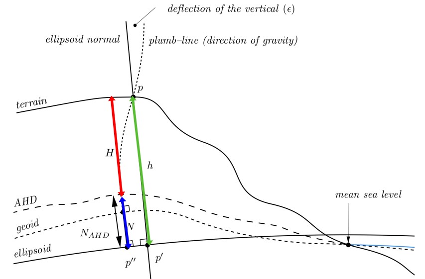
Global Navigation Satellite System (GNSS) ellipsoidal heights (h) can be converted to AHD heights by subtracting the quasigeoid height anomaly (ζ) provided by AUSGeoid models. This is advantageous since GNSS ellipsoidal heights are relatively cheap and easy to obtain in comparison to large-scale levelling campaigns. Derived AHD heights (HAHD) can be determined by subtracting AUSGeoid model values (ζAHD) from GNSS ellipsoidal height observations. The AHD height is approximated by Eq. (1).
HAHD = h - ζAHD (1)
AHD biases and distortions
AHD has the following biases and distortions which mean GNSS users are only capable of deriving AHD heights with accuracy of 6-13 cm across Australia due to:
- The ocean’s time-mean dynamic topography (MDT) and the short tide gauge observation periods, the zero reference of the AHD (MSL at 32 mainland tide gauges) is not coincident with an equipotential surface (e.g. the geoid). The differences largely manifest in a north-south tilt of ~0.7 m in the AHD relative to the geoid across the continent. This tilt can be eliminated by the use of MDT models at tide gauges to correct for the offset between the sea surface recorded at the tide gauges and the geoid.
- The levelling derived heights contain local and regional distortions due to systematic and gross errors in the Australian National Levelling Network (ANLN) that propagated through the national network adjustments completed in 1971.
These attributes of the current official Australian Height Datum are problematic for many users of the datum. In particular, they have a noticeable impact on users requiring consistent heights over large distances (e.g. greater than 10 km) for engineering purposes and scientific studies (e.g. water flow over wide regions). For such cases, the Australian Vertical Working Surface is recommended.